South American Drainage Basins
South American Drainage Basins
30 Minute Resolution
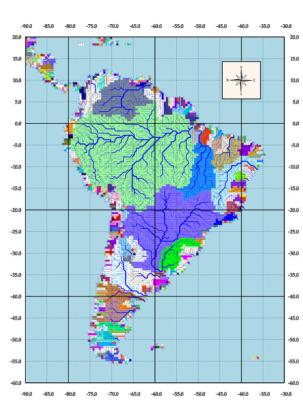
This map is a representation of both drainage basin boundaries and of
a simulated topological network for all river basins within South America.
This data was produced as part of the Global Hydrological Archive and Anaysis
System at the University of New Hampshire. Both data sets are in ASCIIGRID
format and can be ingested into Arc/Info software with the ASCIIGRID command
or into other geographic information system or cartographic software capable
of ingesting a matix of values to form a raster layer. This data is in a
geographic coordinate system.
Sample Drainage Basin Boundary ASCII Data File:
ncols         130
nrows         80
xllcorner     -120
yllcorner     -5
cellsize      0.5
NODATA_value  -9999
1918 98 98 98 98 33 33 33 33 33 33 33 33 33 33 33 33 33 33 33 33 33 33 33 36 36
36 36 36 36 36 36 6 6 6 6 6 6 6 6 6 6 6 6 6 6 6 6 6 6 6 6 6 6 6 6 6 6 6 6 6 6
141 141 6 6 6 6 6 6 141 141 303 417 417 387 387 387 387 552 552 1053 831 2837
1856 1597 1504 -9999 -9999 -9999 -9999 -9999 -9999 -9999 -9999 -9999 -9999
-9999 -9999 -9999 -9999 -9999 -9999 -9999 -9999 -9999 -9999 -9999 -9999 -9999
-9999 -9999 -9999 -9999 -9999 -9999 -9999 -9999 -9999 -9999 -9999 -9999 -9999
-9999 -9999 -9999 -9999 -9999 -9999 -9999
Each value represents a basin identification code number for each
0.5 degree resolution pixel. Values of -9999 are representative of no data.
Sample Simulated Topological Network ASCII Data File:
ncols         130
nrows         80
xllcorner     -120
yllcorner     -5
cellsize      0.5
NODATA_value  -9999
16 64 32 16 16 1 1 1 2 4 8 4 8 16 8 2 4 4 8 32 16 16 16 32 1 4 4 16 1 2 2 4 64
64 1 1 1 1 1 1 2 2 4 4 4 1 1 128 4 4 4 1 2 4 1 2 4 4 4 4 8 16 2 4 32 16 16 16 8
16 4 8 8 2 4 2 2 4 8 2 4 2 2 2 2 2 1 -9999 -9999 -9999 -9999 -9999 -9999 -9999
-9999 -9999 -9999 -9999 -9999 -9999 -9999 -9999 -9999 -9999 -9999 -9999 -9999
-9999 -9999 -9999 -9999 -9999 -9999 -9999 -9999 -9999 -9999 -9999 -9999 -9999
-9999 -9999 -9999 -9999 -9999 -9999 -9999 -9999 -9999 -9999
Each value represents a directionality code for each 0.5 degree
resolution pixel. Values of -9999 are representative of no data. All other
values are as follows. (1 = east, 2 = southeast, 4 = south, 8 = southwest,
16 = west, 32 = northwest, 64 = north, 128 = northeast) "
 Back to R-HydroNET